
Ahaus topographic map
Interactive map
Click on the map to display elevation.
About this map
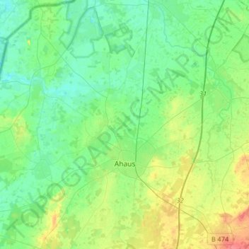
Name: Ahaus topographic map, elevation, terrain.
Location: Ahaus, Kreis Borken, Noordrijn-Westfalen, 48683, Duitsland (52.02106 6.86694 52.18113 7.06730)
Average elevation: 174 ft
Minimum elevation: 118 ft
Maximum elevation: 312 ft
Other topographic maps
Click on a map to view its topography, its elevation and its terrain.
Raesfeld
Duitsland > Noordrijn-Westfalen > Kreis Borken
Raesfeld, Kreis Borken, Noordrijn-Westfalen, 46348, Duitsland
Average elevation: 177 ft
Borken
Duitsland > Noordrijn-Westfalen > Kreis Borken
Borken, Kreis Borken, Noordrijn-Westfalen, 46325, Duitsland
Average elevation: 184 ft
Bocholt
Duitsland > Noordrijn-Westfalen > Kreis Borken
Bocholt, Kreis Borken, Noordrijn-Westfalen, Duitsland
Average elevation: 102 ft