
Bürchen topographic map
Interactive map
Click on the map to display elevation.
About this map
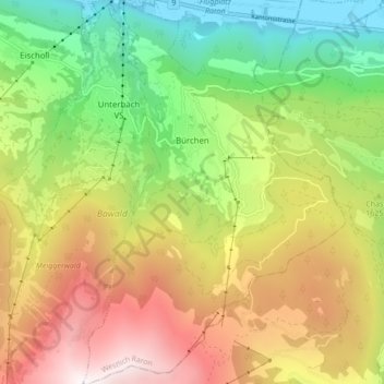
Name: Bürchen topographic map, elevation, terrain.
Location: Bürchen, Rarogne occidental, Valais, 3935, Suisse (46.24295 7.79195 46.30201 7.85041)
Average elevation: 5,318 ft
Minimum elevation: 2,070 ft
Maximum elevation: 9,416 ft
Other topographic maps
Click on a map to view its topography, its elevation and its terrain.
Ausserberg
Suisse > Valais > Rarogne occidental
Ausserberg, Rarogne occidental, Valais, 3938, Suisse
Average elevation: 5,184 ft
Rarogne
Suisse > Valais > Rarogne occidental
Rarogne, Rarogne occidental, Valais, 3942, Suisse
Average elevation: 5,617 ft