
Chatan topographic map
Interactive map
Click on the map to display elevation.
About this map
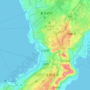
Name: Chatan topographic map, elevation, terrain.
Location: Chatan, Nakagami, Okinawa Prefecture, Japan (26.29319 127.65668 26.34617 127.78589)
Average elevation: 112 ft
Minimum elevation: -3 ft
Maximum elevation: 568 ft
Other topographic maps
Click on a map to view its topography, its elevation and its terrain.
Kitanakagusuku
Kitanakagusuku, Nakagami, Okinawa Prefecture, Japan
Average elevation: 194 ft