
Make a donation
Gear up for your next adventure:
As an Amazon Associate, this site earns from qualifying purchases at no extra cost to you.
Vergato topographic map
Click on the map to display elevation.
Make a donation
Gear up for your next adventure:
As an Amazon Associate, this site earns from qualifying purchases at no extra cost to you.
About this map
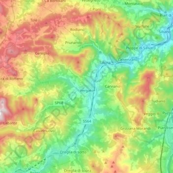
Name: Vergato topographic map, elevation, terrain.
Average elevation: 1,532 ft
Minimum elevation: 459 ft
Maximum elevation: 3,264 ft
Make a donation
Gear up for your next adventure:
As an Amazon Associate, this site earns from qualifying purchases at no extra cost to you.
Other topographic maps
Click on a map to view its topography, its elevation and its terrain.
Venezia
Italy > Emilia-Romagna > Bologna > Monte San Pietro > Monte San Giovanni
Average elevation: 823 ft
Casone di Monteacuto Ragazza
Italy > Emilia-Romagna > Bologna > Monteacuto Ragazza
Average elevation: 1,699 ft
Make a donation
Gear up for your next adventure:
As an Amazon Associate, this site earns from qualifying purchases at no extra cost to you.