
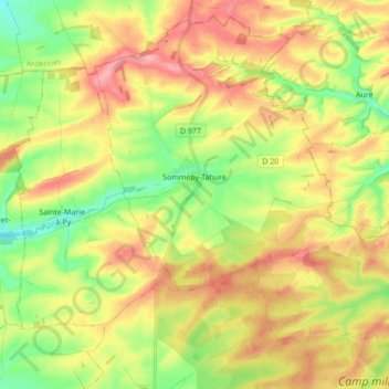
Sommepy-Tahure topographic map
Interactive map
Click on the map to display elevation.
About this map
Name: Sommepy-Tahure topographic map, elevation, terrain.
Average elevation: 531 ft
Minimum elevation: 374 ft
Maximum elevation: 699 ft
Other topographic maps
Click on a map to view its topography, its elevation and its terrain.
Le Bas des Poncets
Frankreich > Grand Est > Marne > Trigny
Le Bas des Poncets, Trigny, Reims, Marne, Grand Est, Metropolitanes Frankreich, 51140, Frankreich
Average elevation: 384 ft
Pringy
Frankreich > Grand Est > Marne
Pringy, Vitry-le-François, Marne, Grand Est, Metropolitanes Frankreich, 51300, Frankreich
Average elevation: 390 ft
Saint-Léonard
Frankreich > Grand Est > Marne
Saint-Léonard, Reims, Marne, Grand Est, Metropolitanes Frankreich, 51500, Frankreich
Average elevation: 295 ft
Verdon
Frankreich > Grand Est > Marne
Verdon, Épernay, Marne, Grand Est, Metropolitanes Frankreich, 51210, Frankreich
Average elevation: 666 ft
Châlons-en-Champagne
Frankreich > Grand Est > Marne
Châlons-en-Champagne, Marne, Grand Est, Metropolitanes Frankreich, 51000, Frankreich
Average elevation: 325 ft