
Mehdia topographic map
Interactive map
Click on the map to display elevation.
About this map
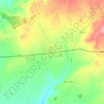
Name: Mehdia topographic map, elevation, terrain.
Location: Mehdia, Aïn Arnat, Daïra Aïn Arnat, Sétif, Algérie (36.15042 5.21525 36.19042 5.25525)
Average elevation: 3,192 ft
Minimum elevation: 2,995 ft
Maximum elevation: 3,409 ft
Other topographic maps
Click on a map to view its topography, its elevation and its terrain.
Timlouka
Algérie > Sétif > Daïra Aïn Arnat > Aïn Arnat
Timlouka, Aïn Arnat, Daïra Aïn Arnat, Sétif, 19017, Algérie
Average elevation: 3,278 ft