Geolocate

Kapadvanj topographic map

Click on the map to display elevation.

Kapadvanj

Kapadvanj is located at 23°01′N 73°04′E / 23.02°N 73.07°E / 23.02; 73.07. It has an average elevation of 69 metres (226 feet).

About this map

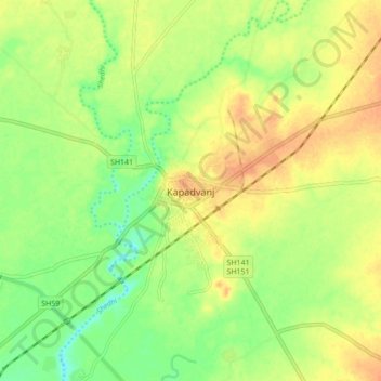
Name: Kapadvanj topographic map, elevation, terrain.

Location: Kapadvanj, Kapadvanj Taluka, Kheda District, Gujarat, 387600, India (22.98324 73.03275 23.06324 73.11275)

Average elevation: 253 ft

Minimum elevation: 187 ft

Maximum elevation: 305 ft

Gear up for your next adventure:

🔭Stargazing Telescopes - Perfect for camping in low-light pollution areas shown on maps
📌Outdoor GPS Map App - Apps and devices for digital topographic navigation
🔭Telescopic Hiking Pole - Adjustable pole for hiking stability
🗺️NatGeo Topo Maps - High-quality waterproof printed topographic maps of US Parks
🪶Survival Guide Book - Expert advice for emergency preparedness

As an Amazon Associate, this site earns from qualifying purchases at no extra cost to you.