
Kasteel Nijenrode topographic map
Interactive map
Click on the map to display elevation.
About this map
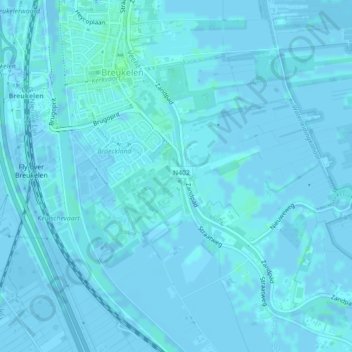
Name: Kasteel Nijenrode topographic map, elevation, terrain.
Average elevation: 3 ft
Minimum elevation: -16 ft
Maximum elevation: 16 ft
Other topographic maps
Click on a map to view its topography, its elevation and its terrain.
Loosdrechtse Plassen
Nederland > Utrecht > Stichtse Vecht
Loosdrechtse Plassen, De Meent, Breukelen, Stichtse Vecht, Utrecht, Nederland, 3621VB, Nederland
Average elevation: -3 ft
Nigtevecht
Nederland > Utrecht > Stichtse Vecht > Nigtevecht
Nigtevecht, Stichtse Vecht, Utrecht, Nederland
Average elevation: -3 ft
Slot Zuylen
Nederland > Utrecht > Stichtse Vecht
Slot Zuylen, Tournooiveld, Op Buuren Park, Oud Zuilen, Stichtse Vecht, Utrecht, Nederland, 3611AS, Nederland
Average elevation: 7 ft