Geolocate

Phaltan topographic map

Click on the map to display elevation.

About this map

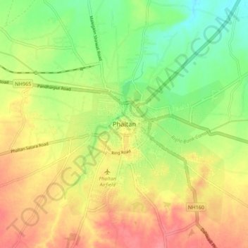
Name: Phaltan topographic map, elevation, terrain.

Location: Phaltan, Satara, Maharashtra, 415523, India (17.95077 74.38988 18.03077 74.46988)

Average elevation: 1,841 ft

Minimum elevation: 1,726 ft

Maximum elevation: 1,949 ft

Gear up for your next adventure:

🛡️Insect Repellent - Protection against bugs during outdoor activities
🧭Outdoor Navigation Book - Learn advanced navigation skills
🎒Day Hiking Backpack - Lightweight backpack perfect for day trips and outdoor adventures
🚁Photography Drones - Capture stunning aerial views of landforms and topography
📱Solar Portable Charger - Solar power bank for charging devices off‑grid

As an Amazon Associate, this site earns from qualifying purchases at no extra cost to you.