
Réhling-Sierbourg topographic map
Interactive map
Click on the map to display elevation.
About this map
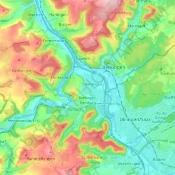
Name: Réhling-Sierbourg topographic map, elevation, terrain.
Location: Réhling-Sierbourg, Landkreis Saarlouis, Sarre, 66780, Allemagne (49.33004 6.53725 49.41939 6.70424)
Average elevation: 820 ft
Minimum elevation: 545 ft
Maximum elevation: 1,332 ft
Other topographic maps
Click on a map to view its topography, its elevation and its terrain.
Bous
Allemagne > Sarre > Landkreis Saarlouis
Bous, Landkreis Saarlouis, Sarre, 66359, Allemagne
Average elevation: 712 ft
Réhling-Sierbourg
Allemagne > Sarre > Landkreis Saarlouis > Rehlingen-Siersburg > Réhling-Sierbourg
Réhling-Sierbourg, Rehlingen-Siersburg, Landkreis Saarlouis, Sarre, 66780, Allemagne
Average elevation: 682 ft
Vaudrevange
Allemagne > Sarre > Landkreis Saarlouis
Vaudrevange, Landkreis Saarlouis, Sarre, 66798, Allemagne
Average elevation: 774 ft