Geolocate

Beaulieu topographic map

Click on the map to display elevation.

About this map

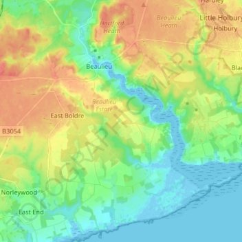
Name: Beaulieu topographic map, elevation, terrain.

Location: Beaulieu, New Forest, Hampshire, England, United Kingdom (50.75844 -1.48390 50.84094 -1.37365)

Average elevation: 62 ft

Minimum elevation: -16 ft

Maximum elevation: 151 ft

Other topographic maps

Click on a map to view its topography, its elevation and its terrain.

Dibden

United Kingdom > England > Hampshire > New Forest

Average elevation: 56 ft

Brook

United Kingdom > England > Hampshire > New Forest > Bramshaw

Average elevation: 213 ft

Winsor

United Kingdom > England > Hampshire > New Forest

Average elevation: 89 ft

Half Moon

United Kingdom > England > Hampshire > New Forest

Average elevation: 118 ft

Ower

United Kingdom > England > Hampshire > New Forest

Average elevation: 79 ft

Gear up for your next adventure:

🧣Hiking Neck Gaiter - Multi‑use neck protection for outdoor weather
🏕️Family Camping Gear - Essentials for group camping trips
🧣Merino Neck Gaiters - Multi-functional headwear for wind and sun protection
🩳Quick‑Dry Hiking Shorts - Comfortable and quick‑dry shorts for summer hiking
🌧️Backpack Rain Cover - Keep gear dry in wet weather

As an Amazon Associate, this site earns from qualifying purchases at no extra cost to you.