
Make a donation
Gear up for your next adventure:
As an Amazon Associate, this site earns from qualifying purchases at no extra cost to you.
Macedonia topographic map
Click on the map to display elevation.
Make a donation
Gear up for your next adventure:
As an Amazon Associate, this site earns from qualifying purchases at no extra cost to you.
About this map
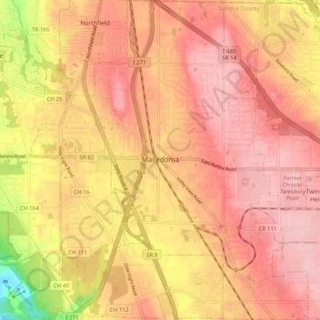
Name: Macedonia topographic map, elevation, terrain.
Location: Macedonia, Summit County, Ohio, 44056, United States (41.27669 -81.53071 41.35026 -81.46332)
Average elevation: 1,017 ft
Minimum elevation: 653 ft
Maximum elevation: 1,184 ft
Summit County trails, hiking, mountain biking, running and outdoor activities
Make a donation
Gear up for your next adventure:
As an Amazon Associate, this site earns from qualifying purchases at no extra cost to you.
Other topographic maps
Click on a map to view its topography, its elevation and its terrain.
Make a donation
Gear up for your next adventure:
As an Amazon Associate, this site earns from qualifying purchases at no extra cost to you.
Make a donation
Gear up for your next adventure:
As an Amazon Associate, this site earns from qualifying purchases at no extra cost to you.
Northampton Center
United States > Ohio > Summit County > Cuyahoga Falls > Northampton Center
Average elevation: 968 ft
Chittendens Corners
United States > Ohio > Summit County > Boston Heights > Chittendens Corners
Average elevation: 988 ft
East Center
United States > Ohio > Summit County > Richfield > East Center
Average elevation: 1,125 ft
Make a donation
Gear up for your next adventure:
As an Amazon Associate, this site earns from qualifying purchases at no extra cost to you.