
德惠市 topographic map
Interactive map
Click on the map to display elevation.
About this map
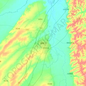
Name: 德惠市 topographic map, elevation, terrain.
Location: 德惠市, 长春市, 吉林省, 130000, 中国 (44.37501 125.53544 44.69501 125.85544)
Average elevation: 591 ft
Minimum elevation: 499 ft
Maximum elevation: 801 ft
德惠市位于吉林省中北部,松辽平原腹地。全市地势南高北低,呈波状起伏,但相对落差不大,大部分海拔高度在149-241米之间。地处东经125°14'- 126°28',北纬44°33'- 44°51',幅员面积3435平方公里。全市年平均气温4℃,降水量520毫米。东南与九台市接壤,西南毗邻长春市郊,西部与农安县以伊通河为界,东北与扶余县、榆树市隔江相望。境内有松花江、饮马河、伊通河等河流。属中温带半湿润季风气候。
Other topographic maps
Click on a map to view its topography, its elevation and its terrain.