Geolocate

Chira topographic map

Click on the map to display elevation.

About this map

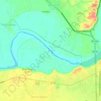
Name: Chira topographic map, elevation, terrain.

Location: Chira, Sullana, Province of Sullana, Piura, Peru (-4.89986 -80.75515 -4.88168 -80.70714)

Average elevation: 164 ft

Minimum elevation: 82 ft

Maximum elevation: 299 ft

Other topographic maps

Click on a map to view its topography, its elevation and its terrain.

Mejia

Peru > Piura > Sullana

Average elevation: 253 ft

Gear up for your next adventure:

📷Action Camera - Capture your outdoor adventures in HD
🧢Outdoor Hiking Hat - Sun protection hat for outdoor explorers
🛡️Insect Repellent - Protection against bugs during outdoor activities
🦺Reflective Outdoor Gear - Safety gear for low‑light conditions
📡Handheld GPS Device - Reliable handheld GPS for outdoor navigation

As an Amazon Associate, this site earns from qualifying purchases at no extra cost to you.