
Molesmes topographic map
Interactive map
Click on the map to display elevation.
About this map
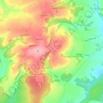
Name: Molesmes topographic map, elevation, terrain.
Average elevation: 958 ft
Minimum elevation: 699 ft
Maximum elevation: 1,207 ft
Other topographic maps
Click on a map to view its topography, its elevation and its terrain.
Taingy
France > Bourgogne-Franche-Comté > Yonne > Les Hauts de Forterre
Taingy, Les Hauts de Forterre, Auxerre, Yonne, Bourgogne-Franche-Comté, France métropolitaine, 89560, France
Average elevation: 978 ft