
Indian Peaks Wilderness topographic map
Interactive map
Click on the map to display elevation.
About this map
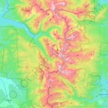
Name: Indian Peaks Wilderness topographic map, elevation, terrain.
Average elevation: 10,105 ft
Minimum elevation: 8,176 ft
Maximum elevation: 13,438 ft
The area encompasses a stretch of the Front Range. It includes 7 peaks over 13,000 feet (4,000 m) in elevation. The highest point is North Arapaho Peak at 13,502 feet (4,115 m). The peaks are all within 100 feet (30 m) of elevation of each other. A portion of the area, encompassing the headwaters of North Boulder Creek, is closed to the public as it is the City of Boulder watershed.
Other topographic maps
Click on a map to view its topography, its elevation and its terrain.
Fraser
United States > Colorado > Grand County
Fraser, Grand County, Colorado, 80442, United States
Average elevation: 8,845 ft
Radium
United States > Colorado > Grand County
Radium, Grand County, Colorado, United States
Average elevation: 7,418 ft
Grand Lake
United States > Colorado > Grand County
Grand Lake, Grand County, Colorado, United States
Average elevation: 8,629 ft
Morse Mountain
United States > Colorado > Grand County
Morse Mountain, Grand County, Colorado, United States
Average elevation: 9,593 ft
Winter Park
United States > Colorado > Grand County
Winter Park, Grand County, Colorado, United States
Average elevation: 10,066 ft
Granby
United States > Colorado > Grand County
Granby, Grand County, Colorado, 80446, United States
Average elevation: 8,383 ft
Lake Granby
United States > Colorado > Grand County
Lake Granby, Grand County, Colorado, United States
Average elevation: 8,556 ft
Rabbit Ears Pass
United States > Colorado > Grand County
Rabbit Ears Pass, Grand County, Colorado, United States
Average elevation: 9,357 ft
Bottle Peak
United States > Colorado > Grand County
Bottle Peak, Grand County, Colorado, United States
Average elevation: 10,771 ft
Elk Mountain
United States > Colorado > Grand County
Elk Mountain, Grand County, Colorado, United States
Average elevation: 10,558 ft
Tabernash
United States > Colorado > Grand County
Tabernash, Grand County, Colorado, 80478, United States
Average elevation: 8,504 ft
Kremmling
United States > Colorado > Grand County
Kremmling, Grand County, Colorado, 80459, United States
Average elevation: 7,385 ft
Mount Flora
United States > Colorado > Grand County
Mount Flora, Grand County, Colorado, United States
Average elevation: 12,231 ft