
Parque Nacional Volcán Isluga topographic map
Interactive map
Click on the map to display elevation.
About this map
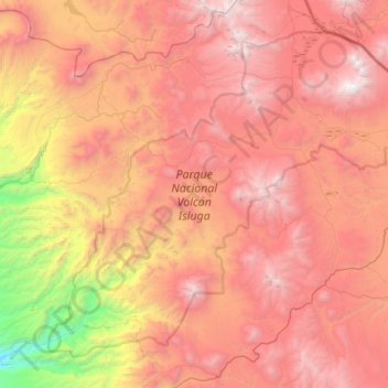
Name: Parque Nacional Volcán Isluga topographic map, elevation, terrain.
Average elevation: 12,831 ft
Minimum elevation: 6,027 ft
Maximum elevation: 18,192 ft
Other topographic maps
Click on a map to view its topography, its elevation and its terrain.
Reserva Nacional Pampa del Tamarugal
Chile > Región de Tarapacá > Huara
Reserva Nacional Pampa del Tamarugal, Ruta 5 Norte, Huara, Provincia del Tamarugal, Región de Tarapacá, Chile
Average elevation: 3,839 ft
Pisagua
Chile > Región de Tarapacá > Huara > Pisagua
Pisagua, Huara, Provincia del Tamarugal, Región de Tarapacá, Chile
Average elevation: 489 ft