
Balaton topographic map
Interactive map
Click on the map to display elevation.
About this map
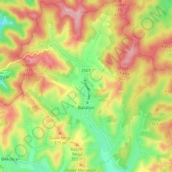
Name: Balaton topographic map, elevation, terrain.
Average elevation: 1,161 ft
Minimum elevation: 879 ft
Maximum elevation: 1,440 ft
Other topographic maps
Click on a map to view its topography, its elevation and its terrain.
Erdőkövesd
Erdőkövesd, Pétervásárai járás, Komitat Heves, Nordungarn, Nördliche Große Tiefebene, 3252, Ungarn
Average elevation: 784 ft
Erlau
Erlau, Kreis Erlau, Komitat Heves, Nordungarn, Nördliche Große Tiefebene, Ungarn
Average elevation: 860 ft