
Bottom House topographic map
Interactive map
Click on the map to display elevation.
About this map
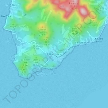
Name: Bottom House topographic map, elevation, terrain.
Location: Bottom House, San Andrés and Providencia, Colombia (13.30945 -81.39670 13.34945 -81.35670)
Average elevation: 151 ft
Minimum elevation: 0 ft
Maximum elevation: 1,132 ft
Other topographic maps
Click on a map to view its topography, its elevation and its terrain.
Saint Andrew
Colombia > San Andrés and Providencia > San Luis
Saint Andrew, San Luis, San Andrés and Providencia, Colombia
Average elevation: 10 ft
San Andrés and Providencia
Colombia > San Andrés and Providencia
San Andrés and Providencia, Colombia
Average elevation: 16 ft