
Thank you for supporting this site ❤️
Make a donation
Make a donation
Gear up for your next adventure:
As an Amazon Associate, this site earns from qualifying purchases at no extra cost to you.
San Vito Lo Capo topographic map
Click on the map to display elevation.
Thank you for supporting this site ❤️
Make a donation
Make a donation
Gear up for your next adventure:
As an Amazon Associate, this site earns from qualifying purchases at no extra cost to you.
About this map
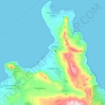
Name: San Vito Lo Capo topographic map, elevation, terrain.
Location: San Vito Lo Capo, Trapani, Sicily, 91030, Italy (38.05821 12.71069 38.18964 12.81132)
Average elevation: 512 ft
Minimum elevation: 0 ft
Maximum elevation: 3,317 ft
Thank you for supporting this site ❤️
Make a donation
Make a donation
Gear up for your next adventure:
As an Amazon Associate, this site earns from qualifying purchases at no extra cost to you.