
Molini topographic map
Interactive map
Click on the map to display elevation.
About this map
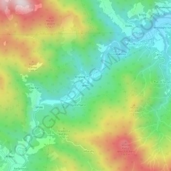
Name: Molini topographic map, elevation, terrain.
Location: Molini, Rezzoaglio, Gênes, Ligurie, 16048, Italie (44.49634 9.35099 44.53634 9.39099)
Average elevation: 3,094 ft
Minimum elevation: 2,198 ft
Maximum elevation: 4,626 ft
Other topographic maps
Click on a map to view its topography, its elevation and its terrain.
Brignole
Italie > Ligurie > Gênes > Rezzoaglio
Brignole, Rezzoaglio, Gênes, Ligurie, 16048, Italie
Average elevation: 3,120 ft