
Erstfeld topographic map
Interactive map
Click on the map to display elevation.
About this map
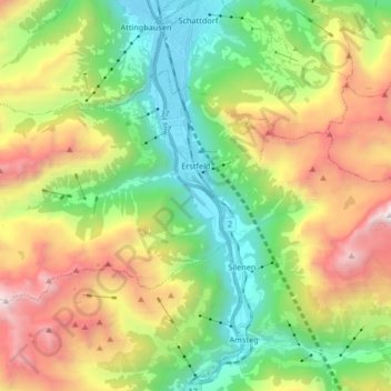
Name: Erstfeld topographic map, elevation, terrain.
Location: Erstfeld, Uri, 6472, Switzerland (46.77637 8.51750 46.84932 8.68302)
Average elevation: 4,843 ft
Minimum elevation: 1,457 ft
Maximum elevation: 10,410 ft
Other topographic maps
Click on a map to view its topography, its elevation and its terrain.
Realp
Switzerland > Uri > Korporation Ursern
Realp, Korporation Ursern, Uri, 6491, Switzerland
Average elevation: 7,487 ft
Hospental
Switzerland > Uri > Korporation Ursern
Hospental, Korporation Ursern, Uri, 6493, Switzerland
Average elevation: 7,034 ft
Abfrutt
Switzerland > Uri > Göschenen
Abfrutt, Göschenen, Uri, 6487, Switzerland
Average elevation: 5,436 ft
Bristen
Switzerland > Uri > Silenen
Bristen, Silenen, Uri, 6475, Switzerland
Average elevation: 3,996 ft
Andermatt
Switzerland > Uri > Korporation Ursern
Andermatt, Korporation Ursern, Uri, 6490, Switzerland
Average elevation: 6,978 ft
Göscheneralp
Switzerland > Uri > Göschenen
Göscheneralp, Göschenen, Uri, 6487, Switzerland
Average elevation: 6,578 ft
3083
Switzerland > Uri > Realp
3083, Realp, Korporation Ursern, Uri, 6491, Switzerland
Average elevation: 8,848 ft