
Departamento San Salvador topographic map
Interactive map
Click on the map to display elevation.
About this map
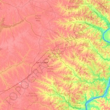
Name: Departamento San Salvador topographic map, elevation, terrain.
Location: Departamento San Salvador, ER., Argentinien (-31.90246 -58.72919 -31.25768 -58.28041)
Average elevation: 171 ft
Minimum elevation: -13 ft
Maximum elevation: 272 ft
Other topographic maps
Click on a map to view its topography, its elevation and its terrain.
Gualeguaychú
Argentinien > ER. > Gualeguaychú
Gualeguaychú, Distrito Costa Uruguay Sur, Departamento Gualeguaychú, ER., 2820, Argentinien
Average elevation: 62 ft