
Naomé topographic map
Interactive map
Click on the map to display elevation.
About this map
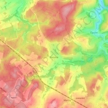
Name: Naomé topographic map, elevation, terrain.
Location: Naomé, Bièvre, Dinant, Province de Namur, Wallonie, Belgique (49.89738 5.04092 49.95092 5.11960)
Average elevation: 1,299 ft
Minimum elevation: 1,109 ft
Maximum elevation: 1,444 ft
Other topographic maps
Click on a map to view its topography, its elevation and its terrain.
Graide
Belgique > Province de Namur > Dinant > Bièvre
Graide, Bièvre, Dinant, Province de Namur, Wallonie, Belgique
Average elevation: 1,234 ft