
Schevenhütte topographic map
Interactive map
Click on the map to display elevation.
About this map
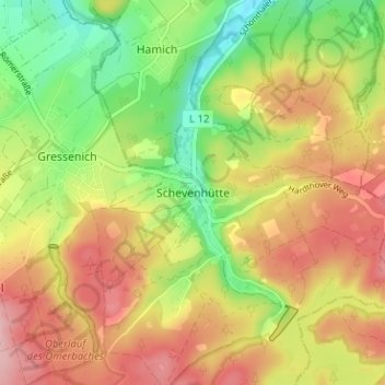
Name: Schevenhütte topographic map, elevation, terrain.
Average elevation: 801 ft
Minimum elevation: 541 ft
Maximum elevation: 1,053 ft
Other topographic maps
Click on a map to view its topography, its elevation and its terrain.
Ellerberg
Deutschland > Nordrhein-Westfalen > Städteregion Aachen > Stolberg > Gressenich
Ellerberg, Gressenich, Stolberg, Städteregion Aachen, Nordrhein-Westfalen, 52224, Deutschland
Average elevation: 801 ft
Werth
Deutschland > Nordrhein-Westfalen > Städteregion Aachen > Stolberg
Werth, Stolberg, Städteregion Aachen, Nordrhein-Westfalen, 52224, Deutschland
Average elevation: 741 ft