
Signal Hill National Historic Site topographic map
Interactive map
Click on the map to display elevation.
About this map
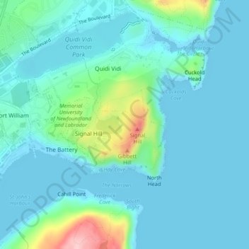
Name: Signal Hill National Historic Site topographic map, elevation, terrain.
Average elevation: 95 ft
Minimum elevation: -3 ft
Maximum elevation: 574 ft
Other topographic maps
Click on a map to view its topography, its elevation and its terrain.
Newfound Pond
Canada > Newfoundland and Labrador > St. John's
Newfound Pond, St. John's, Newfoundland, Newfoundland and Labrador, Canada
Average elevation: 515 ft
Cape Spear
Canada > Newfoundland and Labrador > St. John's
Cape Spear, St. John's, Newfoundland, Newfoundland and Labrador, Canada
Average elevation: 23 ft
Cape Bay
Canada > Newfoundland and Labrador > St. John's
Cape Bay, St. John's, Newfoundland, Newfoundland and Labrador, Canada
Average elevation: 69 ft
Wigmore
Canada > Newfoundland and Labrador > St. John's
Wigmore, St. John's, Newfoundland, Newfoundland and Labrador, Canada
Average elevation: 387 ft
Blackhead
Canada > Newfoundland and Labrador > St. John's > Blackhead
Blackhead, St. John's, Newfoundland and Labrador, Canada
Average elevation: 157 ft