Geolocate

Nagpur topographic map

Click on the map to display elevation.

About this map
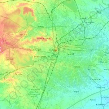
Name: Nagpur topographic map, elevation, terrain.

Location: Nagpur, Nagpur Urban Taluka, Nagpur, Maharashtra, India (21.05297 78.99522 21.23100 79.17885)

Average elevation: 1,014 ft

Minimum elevation: 899 ft

Maximum elevation: 1,276 ft

Other topographic maps

Click on a map to view its topography, its elevation and its terrain.
Digdoh

India > Maharashtra > Nagpur Urban Taluka > Nagpur

Average elevation: 1,070 ft

Gear up for your next adventure:

🪓Survival Multi‑Tool - Versatile tool for camp and trail tasks
🎒Outdoor Daypacks - Lightweight backpacks designed for carrying maps and essential gear
👟Trail Running Shoes - Lightweight shoes for trail runners
🚗GPS Dash Cams - Record your scenic drives through mountain passes and canyons
🛶Inflatable Kayak - Portable kayak for rivers, lakes, and expeditions

As an Amazon Associate, this site earns from qualifying purchases at no extra cost to you.