Geolocate

Kyle topographic map

Click on the map to display elevation.

About this map
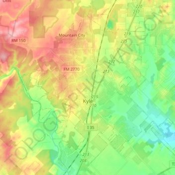
Name: Kyle topographic map, elevation, terrain.

Location: Kyle, Hays County, Texas, 78640, United States (29.94277 -97.97470 30.05550 -97.82502)

Average elevation: 725 ft

Minimum elevation: 551 ft

Maximum elevation: 951 ft

Hays County trails, hiking, mountain biking, running and outdoor activities

Other topographic maps

Click on a map to view its topography, its elevation and its terrain.

Hays City

United States > Texas > Hays County

Average elevation: 955 ft

Driftwood

United States > Texas > Hays County

Average elevation: 1,047 ft

Henly

United States > Texas > Hays County

Average elevation: 1,329 ft

Lone Woman Mountain

United States > Texas > Hays County

Average elevation: 1,250 ft

Henly

United States > Texas > Hays County

Average elevation: 1,329 ft

Yell

United States > Texas > Hays County

Average elevation: 1,322 ft

Gear up for your next adventure:

🚁Photography Drones - Capture stunning aerial views of landforms and topography
🌲Outdoor Survival Books - Best books on survival skills
🧢Sun Protection Hats - Wide-brimmed and UPF-rated hats for high-altitude sun safety
😴Insulated Sleeping Pads - Compact and warm pads for high-elevation camping
🪶Camping Sleeping Pad - Comfortable sleeping pad for backpacking

As an Amazon Associate, this site earns from qualifying purchases at no extra cost to you.