
Caminreal topographic map
Interactive map
Click on the map to display elevation.
About this map
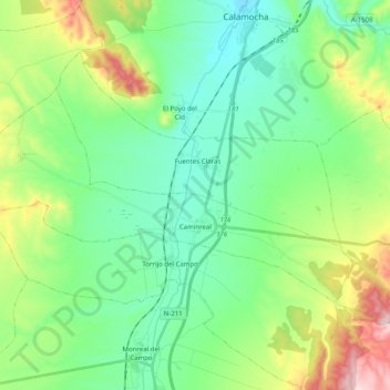
Name: Caminreal topographic map, elevation, terrain.
Location: Caminreal, Jiloca, Teruel, Aragonien, Spanien (40.80947 -1.44431 40.89226 -1.24515)
Average elevation: 3,251 ft
Minimum elevation: 2,867 ft
Maximum elevation: 4,255 ft
Caminreal liegt in den Bergen der Sierra de Cucalón am Río Jiloca in ca. 920 m Höhe und ist ca. 60 km (Fahrtstrecke) in nordnordwestlicher Richtung von der Provinzhauptstadt Teruel entfernt. Durch die Gemeinde führt die Autovía A-23. Das Klima ist trotz der Höhenlage gemäßigt bis warm; Regen (ca. 504 mm/Jahr) fällt übers Jahr verteilt.