
Carbonia topographic map
Interactive map
Click on the map to display elevation.
About this map
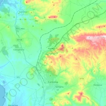
Name: Carbonia topographic map, elevation, terrain.
Location: Carbonia, Sulcis Iglesiente, Sardaigne, 09013, Italie (39.13060 8.43545 39.28334 8.60753)
Average elevation: 535 ft
Minimum elevation: -10 ft
Maximum elevation: 1,988 ft
Other topographic maps
Click on a map to view its topography, its elevation and its terrain.