Geolocate

Novi Grad topographic map

Click on the map to display elevation.

About this map

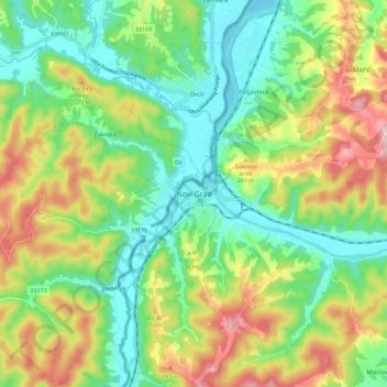
Name: Novi Grad topographic map, elevation, terrain.

Location: Novi Grad, Novi Grad municipality, Republika Srpska, 79220, Bosnia and Herzegovina (45.00899 16.33765 45.08899 16.41765)

Average elevation: 636 ft

Minimum elevation: 358 ft

Maximum elevation: 1,106 ft

Other topographic maps

Click on a map to view its topography, its elevation and its terrain.

Dubac

Bosnia and Herzegovina > Republika Srpska > Dubac

Average elevation: 3,133 ft

Odzak

Bosnia and Herzegovina > Republika Srpska

Average elevation: 2,454 ft

Cerska

Bosnia and Herzegovina > Republika Srpska

Average elevation: 1,942 ft

Grivin

Bosnia and Herzegovina > Republika Srpska

Average elevation: 2,001 ft

Šamac

Bosnia and Herzegovina > Republika Srpska

Average elevation: 282 ft

Gear up for your next adventure:

🧣Hiking Neck Gaiter - Multi‑use neck protection for outdoor weather
🧢Outdoor Hiking Hat - Sun protection hat for outdoor explorers
🧴Hand Sanitizer - Keep hands clean while hiking
🏔️Mountain Trail Maps - High‑detail maps for popular peaks
🪄Magnetic Compass - Accurate compass for navigation

As an Amazon Associate, this site earns from qualifying purchases at no extra cost to you.