
Make a donation
Gear up for your next adventure:
As an Amazon Associate, this site earns from qualifying purchases at no extra cost to you.
Arbuckle topographic map
Click on the map to display elevation.
Make a donation
Gear up for your next adventure:
As an Amazon Associate, this site earns from qualifying purchases at no extra cost to you.
About this map
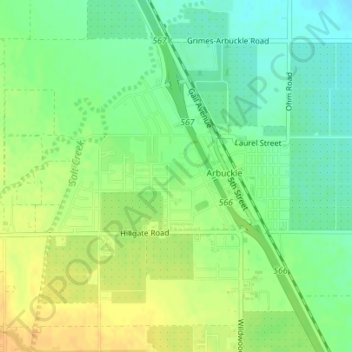
Name: Arbuckle topographic map, elevation, terrain.
Location: Arbuckle, Colusa County, California, 95912, United States (39.00562 -122.07466 39.02865 -122.05139)
Average elevation: 138 ft
Minimum elevation: 89 ft
Maximum elevation: 190 ft
Colusa County trails, hiking, mountain biking, running and outdoor activities
Make a donation
Gear up for your next adventure:
As an Amazon Associate, this site earns from qualifying purchases at no extra cost to you.
Other topographic maps
Click on a map to view its topography, its elevation and its terrain.
Grimes
United States > California > Colusa County
Grimes (formerly Grimes Landing) is a census-designated place in Colusa County, California on the Southern Pacific Railroad. It lies at an elevation of 46 feet (14 m). The two main roads that run through it are State Route 45 and Grimes-Arbuckle Road. Its ZIP code is 95950, and its area code is 530. Grimes's…
Average elevation: 46 ft