Geolocate

Gilmer topographic map

Click on the map to display elevation.

About this map

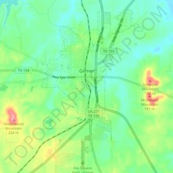
Name: Gilmer topographic map, elevation, terrain.

Location: Gilmer, Upshur County, Texas, United States (32.69083 -94.96785 32.75907 -94.92056)

Average elevation: 381 ft

Minimum elevation: 266 ft

Maximum elevation: 646 ft

Other topographic maps

Click on a map to view its topography, its elevation and its terrain.

Rhonesboro

United States > Texas > Upshur County

Average elevation: 509 ft

Diana

United States > Texas > Upshur County

Average elevation: 312 ft

Diana

United States > Texas > Upshur County

Average elevation: 312 ft

Pattonfield

United States > Texas > Upshur County

Average elevation: 397 ft

Gear up for your next adventure:

👟Men's Trail Runners - Lightweight footwear for fast-paced exploration and light hiking
🚪Portable Camp Chair - Foldable chair for comfort at camp
🧯Emergency Survival Kit - All‑in‑one survival essentials for the backcountry
🧼Biodegradable Camping Soap - Eco‑friendly soap for outdoor hygiene
🧣Hiking Neck Gaiter - Multi‑use neck protection for outdoor weather

As an Amazon Associate, this site earns from qualifying purchases at no extra cost to you.