
Make a donation
Gear up for your next adventure:
As an Amazon Associate, this site earns from qualifying purchases at no extra cost to you.
Essen topographic map
Click on the map to display elevation.
Make a donation
Gear up for your next adventure:
As an Amazon Associate, this site earns from qualifying purchases at no extra cost to you.
Essen
The lowest point can be found in the northern borough of Karnap at 26.5 m (86.9 ft), the highest point in the borough of Heidhausen at 202.5 m (664 ft). The average elevation is 116 m (381 ft).
Make a donation
Gear up for your next adventure:
As an Amazon Associate, this site earns from qualifying purchases at no extra cost to you.
About this map
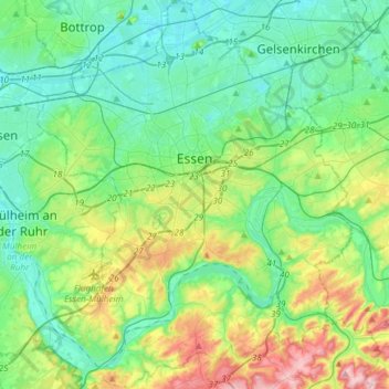
Name: Essen topographic map, elevation, terrain.
Location: Essen, North Rhine-Westphalia, Germany (51.34757 6.89434 51.53423 7.13765)
Average elevation: 282 ft
Minimum elevation: 89 ft
Maximum elevation: 833 ft
Make a donation
Gear up for your next adventure:
As an Amazon Associate, this site earns from qualifying purchases at no extra cost to you.
Other topographic maps
Click on a map to view its topography, its elevation and its terrain.
Ödinghausen
Germany > North Rhine-Westphalia > Oberbergischer Kreis > Nümbrecht
Average elevation: 919 ft
Vogelsang Internationaler Platz (IP)
Germany > North Rhine-Westphalia > Kreis Euskirchen > Schleiden
Average elevation: 1,407 ft
Trupbach
Germany > North Rhine-Westphalia > Kreis Siegen-Wittgenstein > Siegen
Average elevation: 1,083 ft
Make a donation
Gear up for your next adventure:
As an Amazon Associate, this site earns from qualifying purchases at no extra cost to you.
Arpe
Germany > North Rhine-Westphalia > Hochsauerlandkreis > Schmallenberg
Average elevation: 1,385 ft
Make a donation
Gear up for your next adventure:
As an Amazon Associate, this site earns from qualifying purchases at no extra cost to you.
Melbach
Germany > North Rhine-Westphalia > Kreis Siegen-Wittgenstein > Balde
Average elevation: 1,775 ft
Straußberg
Germany > North Rhine-Westphalia > Kreis Minden-Lübbecke > Lübbecke
Average elevation: 577 ft