Make a donation
Gear up for your next adventure:
As an Amazon Associate, this site earns from qualifying purchases at no extra cost to you.
Piedmont topographic map
Click on the map to display elevation.
Make a donation
Gear up for your next adventure:
As an Amazon Associate, this site earns from qualifying purchases at no extra cost to you.
Piedmont
Dugger Mountain, the second highest peak in Alabama with an elevation of 2,140 feet (650 m), is located just outside the city limits of Piedmont, which is the closest city to the peak and wilderness area.
Make a donation
Gear up for your next adventure:
As an Amazon Associate, this site earns from qualifying purchases at no extra cost to you.
About this map
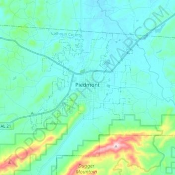
Name: Piedmont topographic map, elevation, terrain.
Location: Piedmont, Calhoun County, Alabama, 36272, United States (33.88185 -85.71455 33.96307 -85.56914)
Average elevation: 863 ft
Minimum elevation: 627 ft
Maximum elevation: 2,100 ft
Calhoun County trails, hiking, mountain biking, running and outdoor activities
Make a donation
Gear up for your next adventure:
As an Amazon Associate, this site earns from qualifying purchases at no extra cost to you.
Other topographic maps
Click on a map to view its topography, its elevation and its terrain.
Make a donation
Gear up for your next adventure:
As an Amazon Associate, this site earns from qualifying purchases at no extra cost to you.
Make a donation
Gear up for your next adventure:
As an Amazon Associate, this site earns from qualifying purchases at no extra cost to you.
Make a donation
Gear up for your next adventure:
As an Amazon Associate, this site earns from qualifying purchases at no extra cost to you.
Make a donation
Gear up for your next adventure:
As an Amazon Associate, this site earns from qualifying purchases at no extra cost to you.
Woodland Park
United States > Alabama > Calhoun County > Anniston > Woodland Park
Average elevation: 804 ft
