
Make a donation
Gear up for your next adventure:
As an Amazon Associate, this site earns from qualifying purchases at no extra cost to you.
Hudson topographic map
Click on the map to display elevation.
Make a donation
Gear up for your next adventure:
As an Amazon Associate, this site earns from qualifying purchases at no extra cost to you.
About this map
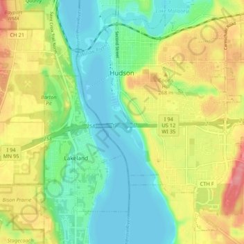
Name: Hudson topographic map, elevation, terrain.
Location: Hudson, Saint Croix County, Wisconsin, 54016, United States (44.93794 -92.77081 44.98918 -92.68940)
Average elevation: 797 ft
Minimum elevation: 669 ft
Maximum elevation: 991 ft
Saint Croix County trails, hiking, mountain biking, running and outdoor activities
Make a donation
Gear up for your next adventure:
As an Amazon Associate, this site earns from qualifying purchases at no extra cost to you.
Other topographic maps
Click on a map to view its topography, its elevation and its terrain.
Larry Forrest Park
United States > Wisconsin > Saint Croix County > Somerset
Average elevation: 906 ft