
Monte Bianco di Courmayeur topographic map
Interactive map
Click on the map to display elevation.
About this map
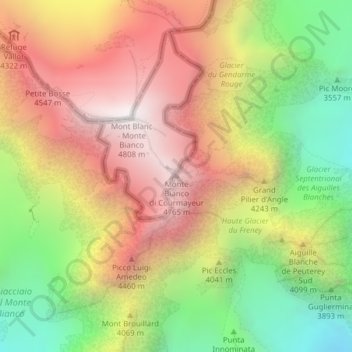
Name: Monte Bianco di Courmayeur topographic map, elevation, terrain.
Location: Monte Bianco di Courmayeur, Courmayeur, Aostatal, Italien (45.82821 6.86999 45.82831 6.87009)
Average elevation: 12,999 ft
Minimum elevation: 10,075 ft
Maximum elevation: 15,761 ft
Other topographic maps
Click on a map to view its topography, its elevation and its terrain.
Ermitage
Italien > Aostatal > Courmayeur > Ermitage
Ermitage, Courmayeur, Aostatal, 11013, Italien
Average elevation: 5,446 ft