
Make a donation
Gear up for your next adventure:
As an Amazon Associate, this site earns from qualifying purchases at no extra cost to you.
Seraidi topographic map
Click on the map to display elevation.
Make a donation
Gear up for your next adventure:
As an Amazon Associate, this site earns from qualifying purchases at no extra cost to you.
Seraidi
The village sits on the Edough massif at an altitude of 860m. It was in the vicinity of this town that the fountain that serviced the Roman aqueducts that fed the cisterns of Hippo began. The highest nearby peak is Kef Sbaâ (lion rock), an apt name as it is claimed that many of the lions of the Coliseum in Rome were taken from the area. The Romans also used the area to hunt elephants, panthers and lynx.
Make a donation
Gear up for your next adventure:
As an Amazon Associate, this site earns from qualifying purchases at no extra cost to you.
About this map
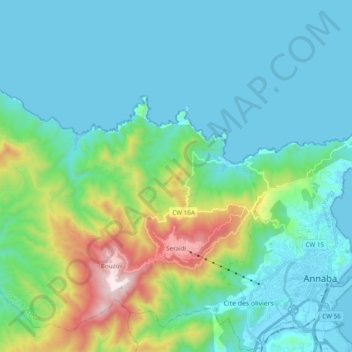
Name: Seraidi topographic map, elevation, terrain.
Location: Seraidi, Annaba District, Annaba, Algeria (36.87498 7.52580 37.01154 7.72000)
Average elevation: 630 ft
Minimum elevation: -3 ft
Maximum elevation: 3,284 ft
Make a donation
Gear up for your next adventure:
As an Amazon Associate, this site earns from qualifying purchases at no extra cost to you.