
Borgercompagnie topographic map
Interactive map
Click on the map to display elevation.
About this map
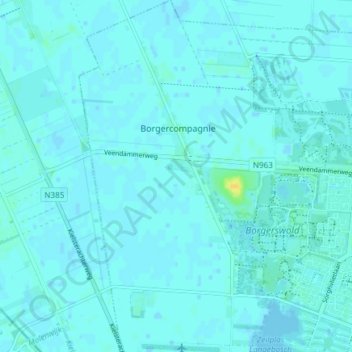
Name: Borgercompagnie topographic map, elevation, terrain.
Location: Borgercompagnie, Veendam, Groningen, Nederland (53.08400 6.80167 53.12884 6.84204)
Average elevation: 7 ft
Minimum elevation: -10 ft
Maximum elevation: 62 ft
Other topographic maps
Click on a map to view its topography, its elevation and its terrain.
Korte Akkers
Nederland > Groningen > Veendam
Korte Akkers, Veendam, Groningen, Nederland, 9644 XS, Nederland
Average elevation: 7 ft
Ommelanderwijk
Nederland > Groningen > Veendam
Ommelanderwijk, Veendam, Groningen, Nederland, 9644 TN, Nederland
Average elevation: 7 ft