Geolocate

Eti Osa topographic map

Interactive map

Click on the map to display elevation.

About this map

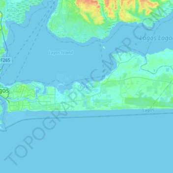
Name: Eti Osa topographic map, elevation, terrain.

Location: Eti Osa, Lagos, Nigeria (6.39441 3.39803 6.52623 3.67363)

Average elevation: 7 ft

Minimum elevation: -13 ft

Maximum elevation: 112 ft

Other topographic maps

Click on a map to view its topography, its elevation and its terrain.

Lagos Island

Nigeria > Lagos > Lagos Island

Lagos Island, Lagos, Nigeria

Average elevation: 20 ft

Lagos Mainland

Nigeria > Lagos > Lagos Mainland

Lagos Mainland, Lagos, YABA, Nigeria

Average elevation: 10 ft

Badagry

Nigeria > Lagos > Badagry

Badagry, Lagos, Nigeria

Average elevation: 33 ft

Kosofe

Nigeria > Lagos > Kosofe

Kosofe, Lagos, 100234, Nigeria

Average elevation: 23 ft

Ikeja

Nigeria > Lagos > Ikeja > Ikeja

Ikeja, Lagos, 100282, Nigeria

Average elevation: 66 ft

Ojota

Nigeria > Lagos > Ojota

Ojota, Kosofe, Lagos, 100281, Nigeria

Average elevation: 52 ft