
Le Forest topographic map
Interactive map
Click on the map to display elevation.
About this map
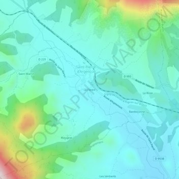
Name: Le Forest topographic map, elevation, terrain.
Average elevation: 2,782 ft
Minimum elevation: 2,362 ft
Maximum elevation: 4,488 ft
Other topographic maps
Click on a map to view its topography, its elevation and its terrain.
Saint-Martin
France > Provence-Alpes-Côte d'Azur > Hautes-Alpes > Saint-Pierre-d'Argençon
Saint-Martin, Saint-Pierre-d'Argençon, Gap, Hautes-Alpes, Provence-Alpes-Côte d'Azur, France métropolitaine, 05140, France
Average elevation: 3,038 ft