
Aranhas topographic map
Interactive map
Click on the map to display elevation.
About this map
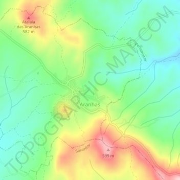
Name: Aranhas topographic map, elevation, terrain.
Location: Aranhas, Penamacor, Castelo Branco, Portugal (40.09831 -7.14334 40.12527 -7.10556)
Average elevation: 1,581 ft
Minimum elevation: 1,329 ft
Maximum elevation: 2,001 ft
Other topographic maps
Click on a map to view its topography, its elevation and its terrain.
Serra de Opa
Portugal > Castelo Branco > Penamacor
Serra de Opa, Penamacor, Castelo Branco, 6090-723, Portugal
Average elevation: 2,047 ft