Geolocate

Oundle topographic map

Click on the map to display elevation.

About this map

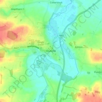
Name: Oundle topographic map, elevation, terrain.

Location: Oundle, North Northamptonshire, England, United Kingdom (52.46712 -0.52758 52.49437 -0.44484)

Average elevation: 121 ft

Minimum elevation: 56 ft

Maximum elevation: 243 ft

Other topographic maps

Click on a map to view its topography, its elevation and its terrain.

Mawsley

United Kingdom > England > North Northamptonshire

Average elevation: 423 ft

Laxton

United Kingdom > England > North Northamptonshire

Average elevation: 282 ft

Gear up for your next adventure:

🧤Tactile Hiking Gloves - Keep hands warm while operating GPS and smartphone screens
🪵Folding Camp Saw - Compact saw for wood and campsite work
🦶Carbon Trekking Poles - Reduce knee impact on steep descents with ultra-light poles
🔦Powerful Headlamps - Ultra-bright hands-free lighting for night navigation
🪶Camping Sleeping Pad - Comfortable sleeping pad for backpacking

As an Amazon Associate, this site earns from qualifying purchases at no extra cost to you.