
Shëngjin topographic map
Interactive map
Click on the map to display elevation.
About this map
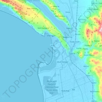
Name: Shëngjin topographic map, elevation, terrain.
Average elevation: 217 ft
Minimum elevation: -23 ft
Maximum elevation: 2,402 ft
Other topographic maps
Click on a map to view its topography, its elevation and its terrain.
Domgjon
Albania > Northern Albania > Lezhë County
Domgjon, Fan, Bashkia Mirditë, Lezhë County, Northern Albania, 4608, Albania
Average elevation: 2,526 ft
Munellë
Albania > Northern Albania > Lezhë County
Munellë, Fan, Bashkia Mirditë, Lezhë County, Northern Albania, 4608, Albania
Average elevation: 3,885 ft
Bashkia Kurbin
Albania > Northern Albania > Lezhë County
Bashkia Kurbin, Lezhë County, Northern Albania, Albania
Average elevation: 768 ft
Trojes
Albania > Northern Albania > Lezhë County > Kthellë
Trojes, Kthellë, Bashkia Mirditë, Lezhë County, Northern Albania, 4606, Albania
Average elevation: 955 ft