
Make a donation
Gear up for your next adventure:
As an Amazon Associate, this site earns from qualifying purchases at no extra cost to you.
Santa Cruz topographic map
Click on the map to display elevation.
Make a donation
Gear up for your next adventure:
As an Amazon Associate, this site earns from qualifying purchases at no extra cost to you.
About this map
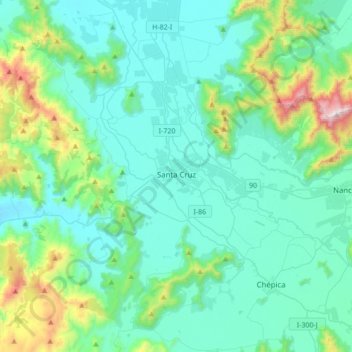
Name: Santa Cruz topographic map, elevation, terrain.
Average elevation: 978 ft
Minimum elevation: 384 ft
Maximum elevation: 3,917 ft
Make a donation
Gear up for your next adventure:
As an Amazon Associate, this site earns from qualifying purchases at no extra cost to you.
Other topographic maps
Click on a map to view its topography, its elevation and its terrain.
Sierras de Bellavista Alto
Chile > O'Higgins Region > Provincia de Colchagua > San Fernando
Average elevation: 3,694 ft
Río del Valle
Chile > O'Higgins Region > Provincia de Colchagua > San Fernando
Average elevation: 6,552 ft
Termas del Flaco
Chile > O'Higgins Region > Provincia de Colchagua > San Fernando
Average elevation: 6,670 ft
Volcán Tinguiririca
Chile > O'Higgins Region > Provincia de Colchagua > San Fernando
Average elevation: 13,091 ft
Make a donation
Gear up for your next adventure:
As an Amazon Associate, this site earns from qualifying purchases at no extra cost to you.