
Glenrothes topographic map
Interactive map
Click on the map to display elevation.
About this map
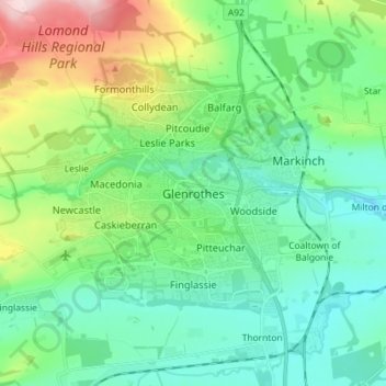
Name: Glenrothes topographic map, elevation, terrain.
Location: Glenrothes, Fife, Scotland, KY7 5NN, United Kingdom (56.15619 -3.21163 56.23619 -3.13163)
Average elevation: 348 ft
Minimum elevation: 105 ft
Maximum elevation: 1,063 ft
Other topographic maps
Click on a map to view its topography, its elevation and its terrain.
Kirkcaldy
United Kingdom > Scotland > Fife
Kirkcaldy, Fife, Scotland, KY1 1JA, United Kingdom
Average elevation: 164 ft