
Melgar topographic map
Interactive map
Click on the map to display elevation.
About this map
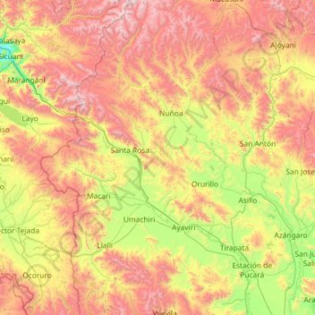
Name: Melgar topographic map, elevation, terrain.
Location: Melgar, Puno, Peru (-15.19489 -71.11809 -14.07474 -70.26651)
Average elevation: 14,183 ft
Minimum elevation: 11,512 ft
Maximum elevation: 18,127 ft
Other topographic maps
Click on a map to view its topography, its elevation and its terrain.
San Antonio de Putina
Peru > Puno > Quilcapuncu
San Antonio de Putina, Quilcapuncu, San Antonio de Putina, Puno, Peru
Average elevation: 14,518 ft