
Make a donation
Gear up for your next adventure:
As an Amazon Associate, this site earns from qualifying purchases at no extra cost to you.
Waitsfield topographic map
Click on the map to display elevation.
Make a donation
Gear up for your next adventure:
As an Amazon Associate, this site earns from qualifying purchases at no extra cost to you.
About this map
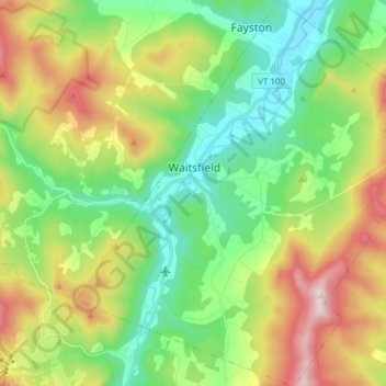
Name: Waitsfield topographic map, elevation, terrain.
Location: Waitsfield, Washington County, Vermont, United States (44.13026 -72.86871 44.23957 -72.73779)
Average elevation: 1,391 ft
Minimum elevation: 607 ft
Maximum elevation: 2,851 ft
Washington County trails, hiking, mountain biking, running and outdoor activities
Make a donation
Gear up for your next adventure:
As an Amazon Associate, this site earns from qualifying purchases at no extra cost to you.
Other topographic maps
Click on a map to view its topography, its elevation and its terrain.
Make a donation
Gear up for your next adventure:
As an Amazon Associate, this site earns from qualifying purchases at no extra cost to you.
North Montpelier
United States > Vermont > Washington County > East Montpelier
Average elevation: 912 ft