
Ettington CP topographic map
Interactive map
Click on the map to display elevation.
About this map
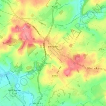
Name: Ettington CP topographic map, elevation, terrain.
Average elevation: 292 ft
Minimum elevation: 151 ft
Maximum elevation: 463 ft
Other topographic maps
Click on a map to view its topography, its elevation and its terrain.
Long Marston CP
United Kingdom > England > Warwickshire > Stratford-on-Avon
Long Marston CP, Stratford-on-Avon, Warwickshire, England, United Kingdom
Average elevation: 148 ft
Harbury
United Kingdom > England > Warwickshire > Stratford-on-Avon > Harbury
Harbury, Stratford-on-Avon, Warwickshire, England, United Kingdom
Average elevation: 312 ft