
Kerpen topographic map
Interactive map
Click on the map to display elevation.
About this map
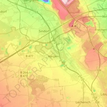
Name: Kerpen topographic map, elevation, terrain.
Location: Kerpen, Rhein-Erft-Kreis, Nordrhein-Westfalen, Deutschland (50.82195 6.54949 50.92542 6.80524)
Average elevation: 322 ft
Minimum elevation: -217 ft
Maximum elevation: 676 ft
Other topographic maps
Click on a map to view its topography, its elevation and its terrain.
Elsdorf
Deutschland > Nordrhein-Westfalen > Rhein-Erft-Kreis
Elsdorf, Rhein-Erft-Kreis, Nordrhein-Westfalen, 50189, Deutschland
Average elevation: 217 ft
Mödrath
Deutschland > Nordrhein-Westfalen > Rhein-Erft-Kreis > Kerpen
Mödrath, Kerpen, Rhein-Erft-Kreis, Nordrhein-Westfalen, 50171, Deutschland
Average elevation: 269 ft
Hürth
Deutschland > Nordrhein-Westfalen > Rhein-Erft-Kreis
Hürth, Rhein-Erft-Kreis, Nordrhein-Westfalen, 50354, Deutschland
Average elevation: 256 ft